

 Sardinia South - Portoscuso & Sant'Antioco +39 345 5293 885 / 0781 189 0909
 Guide Coast TO Coast South West Sardinia
The true splendor of South West Sardinia are certainly its coasts full of long beaches and crystal clear sea. But what makes them unique in its kind is the union with history due to the presence of archaeological finds dating back to pre-Roman times, Spanish towers and mining landscapes. Let’s go in order and begin our journey starting from the South West and the Costa Verde counterclockwise towards the extreme South of Sardinia up to Chia Domus de Maria.
Piscinas & Costa Verde is one of the most pristine and wild places on the West coast. Reaching Piscinas is not among the easiest routes but I assure you that once you reach them they will leave you speechless. The beach can be reached in two ways: from Guspini by going around the mines or from Arbus going down towards Ingurtosu and then Piscinas. In both solutions, from the SS 131, take the San Gavino-Guspini crossroads and go in the direction of Guspini or Arbus depending on your choice. Once in Guspini continue in the direction of Montevecchio (6 km) and from here take the signs for the beach of Piscinas (the road is unpaved for 10 km). Here you can admire fascinating landscapes and the famous mines of the Arburese area.

Passing through Arbus instead, you reach the inhabited center and continue towards Ingurtosu. After about 6 km from the village of Arbus, a crossroads for Ingurtosu is found on the right. Once in the small mining hamlet, continue to the beach of Piscinas (the road is signposted).
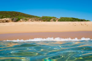
Another destination to absolutely reach is Scivu beach, an unspoilt jewel on the central-western coast of the island: three kilometers of sand dunes, turquoise and emerald green sea and lush vegetation all around. Reaching Scivu, like Piscinas, is not very simple but we must keep in mind that we are not driving along boring highways but we find ourselves in the middle of uncontaminated landscapes surrounded by Mediterranean scrub and breathtaking cliffs.
If you arrive from South West Sardinia, you must follow the signs for Masua and continue to Bugerru. Once in Bugerru continue towards Monte Cidro ss126 and follow the signs for Scivu. From Cagliari we recommend the SS131 for Guspini.
Continuing our journey towards South West Sardinia in the Bugerru area. The first beach we meet is Capo Pecora, a cove characterized by cliffs overlooking the sea, granite rocks, sparse vegetation and the wind. A place far from everything and everyone, harsh and desolate, but inviolate, unforgettable and suggestive for those who love the sea, breathtaking landscapes and for those who love to immerse themselves in the wildest and most uncontaminated nature. You can reach Capo Pecora by arriving in Bugerru and once you have passed the beach of San Nicolò you will arrive at your destination in 15 minutes by following the signs for the beach.

As already mentioned, along the way you will cross the kilometre-long beach of San Nicolò. The beach is immense and if you are looking for some privacy, especially in the months of July and August, it is ideal.
San Nicolò is the ideal destination for both families and couples looking for a bit of peace characterized by a long stretch of coarse golden sand, with harmonious dunes covered with a dense undergrowth of pines, junipers, mastic trees and Mediterranean scrub. The view from the southern cliff is truly fascinating: the green of the vegetation in contrast with the white of the limestone rocks, the blue of the sea and the gold of the beach. A particular and interesting landscape. The sea has a shallow, sandy bottom, with crystalline waters of changing color between green and blue and the presence of rocks in the southern part. Ideal destination for lovers of wave surfing and kite surfing.

We conclude the visit of Bugerru with the most famous and suggestive of the area and I dare say among the best of South West Sardinia or Cala Domestica.
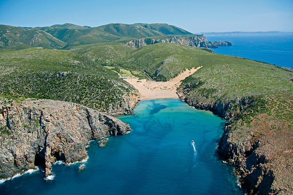
Cala Domestica is an enchanting inlet framed by high cliffs and dominated by a Spanish tower, where mining history and wild nature merge into a single scenario. Reaching the beach is very simple. Coming from the provincial ss126 coming from Iglesias or Carbonia, turn for Masua and upon reaching the latter continue until the indication for Cala Domestica.
Masua & Nebida are two coastal towns not far from each other known for the mining activities that were interrupted at the end of the Second World War. The evolution of the territory has led these two locations in Southern Sardinia to be one of the most interesting and evocative places, both for its history and for its landscapes, of the Sulcis Iglesiente.
We are in Porto Flavia Masua beach and this is the view from the sea towards the mine where at the end of the 19th century the minerals extracted from the rock were loaded by ship. We strongly advise you to visit the mine and in the summer months you cannot help but stop at the beach of Porto Flavia and its breathtaking panorama! A stack, a few hundred meters from the coast, rises majestically over the sea called Pan di Zucchero.


No less is the spectacle that can be seen from the cliff of Nebida and its Belvedere that you will encounter continuing south from Masua. The Belvedere di Nebida is located at the exit of the village on the right side of the road with parking. Once parked, you will easily find the route by following the signs for the Belvedere which can be reached in 5 minutes. Arrived on the spot, about 50 meters above sea level, the sensation will be that of getting lost in the void with the sound of the waves crashing on the cliff at the foot of the beautiful Laveria la Marmora. Our advice is to head to this fantastic place at sunset.
We leave Nebida and head south along the panoramic road where you can’t help but stop at the lay-bys to admire the whole coast and take some souvenir photos.
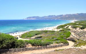
On your right you can admire the Laveria la Marmora and the rock of Pan di Zucchero in the distance, and on your left the bay of Fontanamare about two kilometers long. The beach, given its long expanse, has 4 entrances. In order we will find Fontanamare, Spiaggia di Mezzo, Punta S’Arena and Porto Paglia. To reach the first Fontanamare entrance follow the signs from ss126 for Masua. The entrances to Spiaggia di Mezzo and Punta S’Arena are still on ss126 near Gonnesa. The entrance to Porto Paglia is located on the panoramic ss108 for Portoscuso you will easily find the indications along the road.
We have arrived in the center of South-West Sardinia in the small village of Portoscuso, a strategic destination where we advise you to look for a base to be able to move easily both westward and the Costa Verde and to the extreme south in the bay of Chia Domus de Maria.

Portoscuso is an ancient coastal village of Spanish origin. The village offers one of the best equipped marinas in the south of the island and a port where it is possible to embark for the island of San Pietro. Portopaglietto is the town’s beach which stretches for about 400 meters facing south in an inlet bordered by rocks and therefore always sheltered from the mistral wind which dominates the whole island. Not far from the beach of Portopaglietto, following the promenade that runs along the side with the Spanish Tower, we arrive at the small beach of la Caletta bordering the ancient village of la Tonnara Su Pranu.
We leave Portoscuso and head towards the port to embark towards the island of San Pietro “Carloforte“. Only 45 minutes for the trip. The cost is around €10 per person round trip.
The Island of San Pietro is together with the Island of S.Antioco one of the two main islands of the Sulcis archipelago. Its 33 km of coastline is mostly rocky. Along the western and northern coasts there are some caves, inlets, cliffs and natural pools with several small beaches that can sometimes only be reached by sea. The western coast has sheer cliffs overlooking the sea and is dominated by the Capo Sandalo lighthouse. The east coast, on which the port of Carloforte is also located, is instead low, flat and sandy. To better understand in detail, we refer you to the page dedicated to the island which offers so much both for the coasts and its activities and for its small town Carloforte.

At the end of our tour around the Island of San Pietro we have two options: either to return to Portoscuso or to embark directly for the Island of S.Antioco. The small port from Carloforte is the village of Calasetta.
If you are visiting the island for a whole day, I doubt you still have the energy to continue your journey towards S.Antioco so our advice is to return to your accommodation in Portoscuso and surroundings. The island of S.Antioco can also be reached by land thanks to the isthmus that connects it to Sardinia. This will allow you to visit the island in complete calm, which offers not only beautiful beaches but also various archaeological sites.
Geographically, the town is located on the north-western coast of the island of S.Antioco. Calasetta is known as “la bianca“, due to the prevailing color of the houses. The white lime, in fact, the blue of the sky and the sea, and the green of the junipers on the beaches are characteristic. The territory of Calasetta offers numerous beaches. Its coast is high and rocky to the west and low and sandy to the northeast. The coastline has undergone three large fractures which correspond to three wonderful beaches: “Spiaggiagrande” or “Porto Maggiore“, the “Salina” and “Sottotorre“. Of incomparable beauty is the presence of a rocky bastion to the west which extends in depth up to 10 m and which has contributed to the creation of impressive caves and stacks. One of the most evocative examples of the work of the sea is undoubtedly “The nest of the sparrows”, a pair of stacks emerging from the water so called for the numerous birds that take refuge there. Geographically, the town is located on the north-western coast of the island of S.Antioco. Calasetta is known as “la bianca“, due to the prevailing color of the houses. The white lime, in fact, the blue of the sky and the sea, and the green of the junipers on the beaches are characteristic. The territory of Calasetta offers numerous beaches. Its coast is high and rocky to the west and low and sandy to the northeast. The coastline has undergone three large fractures which correspond to three wonderful beaches: “Spiaggiagrande” or “Porto Maggiore“, the “Salina” and “Sottotorre“. Of incomparable beauty is the presence of a rocky bastion to the west which extends in depth up to 10 m and which has contributed to the creation of impressive caves and stacks. One of the most evocative examples of the work of the sea is undoubtedly “The nest of the sparrows”, a pair of stacks emerging from the water so called for the numerous birds that take refuge there.

We reach the exit of the town and head, following the signs, towards S.Antioco you can’t go wrong!

The town of Sant’Antioco from which the island takes its name is very interesting above all for its origins dating back to the 8th century BC. and for this reason it is considered one of the oldest cities in Italy. For this you must absolutely visit its archaeological areas located inside and outside the city. Its main beaches are Portixeddu, Malatroxia, Coecuaddus, Turri, Capo Sperone and Cala Luna but in addition to these, Sant’Antioco also offers many rocky seaside coves located on the western coast of the island.
We leave the island of Sant’Antioco through the isthmus that connects it to the island of Sardinia and head towards the extreme south towards Porto Pino Sant’Anna Arresi. From ss126 take the first right for Tratalias and after 3.2 km for Giba. Along the way, you will come across the beaches of Porto Botte known for Kite Surfing & Windsurfing and near Masainas the beach of Is Solinas. As a point of reference for Is solinas beach, along the road that will take you to Porto Pino, you will come across a roundabout where you will have to turn right to get to the beach. The beach of Is Solinas is over a kilometer long, overlooks the Gulf of Palmas and is in a sheltered position also because it faces the east coast of the island of Sant’Antioco. The sandy arch, which is also extended in width, is closed on the left by a protrusion of red earth, while on the right it continues as far as the eye can see towards Porto Botte and beyond. Immediately behind it continues with an expanse of dunes; it still follows a mixed band of woodland and scrub, then two ponds stretch out, one called Porto Botte, the other Baiocca, which are populated by aquatic birds, including flamingos: for this reason some paths have been traced along the banks for nature lovers. The beach is made of light gray and very clear sand, thin and deep; at times it is covered by algae washed ashore by the waves; the water, tending to light blue, is very clear; the seabed, which slowly deepens, is also suitable for children.

After the roundabout for Is Solinas we continue towards Porto Pino following the road signs. If you plan to visit the Porto Pino Dunes, pay close attention because the road is indicated but with a “recovery” sign just before the entrance to the town of Porto Pino.

Porto Pino is a fraction of the municipality of Sant’Anna Arresi and a reference seaside resort in the lower Sulcis. The main beach of Porto Pino, about four kilometers long, is divided into two parts by an old ‘sea intake’ for the ponds. The ‘first beach’, not far from the car parks, is characterized by greyish sand, while the ‘second’, set between lagoons and pine forests, is of very white sand and borders Is Arenas Biancas, high white dunes in the territory of Teulada, also called Le Dune, another dazzling kilometre-long expanse of soft sandy hills reaching thirty meters in height.
It has been a very long journey so far and even if in such a small territory it requires a great expenditure of time and energy for this we advise you, in order not to run into useless waste of time, to focus carefully on your needs (beaches, museums, archeology, etc.) according to our guide.
We have arrived at the extreme south of the western coast of Sardinia in the territory of Teulada & Domus de Maria. From Porto Pino follow the signs for Teulada and continue on the ss195.
.
On the ss195 the first turn we meet is for Porto Tramatzu one of the pearls of Teulada. The jagged coast alternates rocky promontories that plunge overhanging the sea to inlets where there are coves with very white sand and crystalline waters. Malfatano pond, Capo Malfatano and Capo Teulada, the extreme southern tip of Sardinia, are of considerable scenic and naturalistic interest. The main beaches in the Teulada area are: Malfatano, Tuerredda, Perdalonga and, within the military camp of Capo Teulada, the beach of Porto Zafferano, which can only be accessed by sea and only at certain times of the year.

Let’s leave the beautiful Tuerredda behind us, even if unfortunately very crowded in the summer months, and take the sp71 again for a few km towards Chia Domus de Maria.